M2 Blog: M2's Role in the Establishment and Protection of MPAs
Three case studies analyzing M2 data
M2 Blog: M2's Role in the Establishment and Protection of MPAs
Posted by M2 Team
July 21, 2026
One of the key requirements for successful marine protected areas (MPAs) is understanding and managing human activities within their boundaries. Marine Monitor (M2) was designed to support MPA managers, enforcement officers, and researchers by providing high resolution data on vessel activity in coastal MPAs. These areas are of special interest because they often have high value to local communities but no simple way to comprehensively document the types of activities that happen, like subsistence and small-scale commercial fishing and recreational activities.
The M2 system addresses this gap by tracking the behavior of these vessels, measuring exactly when and where their activity happens and shifts around MPA boundaries. When behavior is understood, the most effective actions for enhancing conservation become clear.
We present three case studies demonstrating how M2 data users analyzed activity patterns at different MPA stages of implementation:
- An existing MPA in California,
- A recently established MPA in Hawai’i, and
- Unprotected waters in Costa Rica where local partners advocate for MPA designation.
These data-driven metrics provided by M2 help quantify both conservation success and showcase the potential for coastal MPAs around the world.
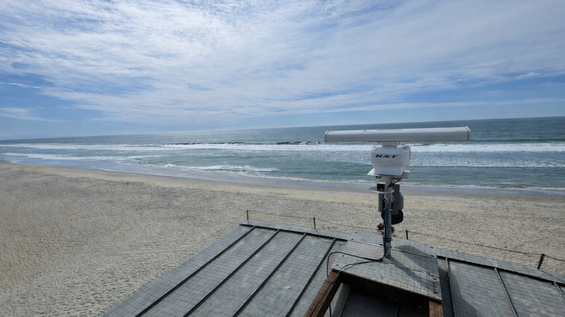
The M2 radar system monitoring the Swami’s State Marine Conservation Area in California
Encinitas, California: M2 Supports Enforcement with Data
The M2 system deployed to Encinitas, California monitors the Swami’s State Marine Conservation Area, the largest MPA in the greater San Diego area. In December 2020, two months into its deployment, the M2 radar system tracked a commercial passenger fishing vessel idling in the northwest corner of the MPA. At the same time, California Department of Fish and Wildlife (CDFW) wardens arrived on scene, and upon seeing the vessel fishing within the MPA boundaries, boarded the vessel and issued a citation. Following a year of litigation, CDFW announced in a press release that a judge had imposed a significant fine on the vessel owners, the first of its kind after a recently passed bill increased penalties for MPA offenders in the state.
Data collected by the M2 system were utilized by prosecutors in the case and ultimately helped secure a guilty plea.
The M2 system, which continues to monitor the MPA today, also provides valuable ongoing information about vessel traffic. When the citation occurred, individual vessels were spending more than an hour inside MPA boundaries on average. In the two years following the publication of the press release, vessels spent 45% less time inside the MPA boundaries, rarely spending more than thirty minutes. This reduction in MPA activity is likely related to multiple factors, such as the effects from the COVID-19 pandemic, patrol efforts, or shifts in species abundance. However, the M2 system provides a measure of human pressure in and around the MPA over time, regardless of why or how it’s changing.
This M2 system was deployed in partnership with WILDCOAST and Global Conservation. Read the press release from CDFW here:
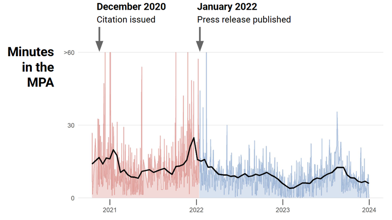
Average time vessels spent inside the Swami’s State Marine Conservation Area before a high profile MPA citation, during the litigation, and following a press release about the outcome of the case
Miloli'i, Hawaii: M2 Helps Communities Monitor Fishing Areas
Since 2021, an M2 system has helped monitor vessel traffic near the Village of Miloliʻi on Hawaiʻi Island. Prior to the deployment of M2, scientists with the Hawai'i Marine Education and Research Center (HawaiiMERC) documented that 67% of the local adult reef fish population had been lost to overfishing and poaching from 2008 to 2018. Thanks to years of dialogue between the community and state agencies, regulatory rules for the Miloli'i Community-based Subsistence Fishing Area (CBSFA) were officially adopted in 2022 to prohibit and limit certain types of fishing. The CBSFA is a culturally-based marine managed area, intended to preserve and sustain the local reef ecosystem for long-term subsistence and Miloli'i cultural practices.
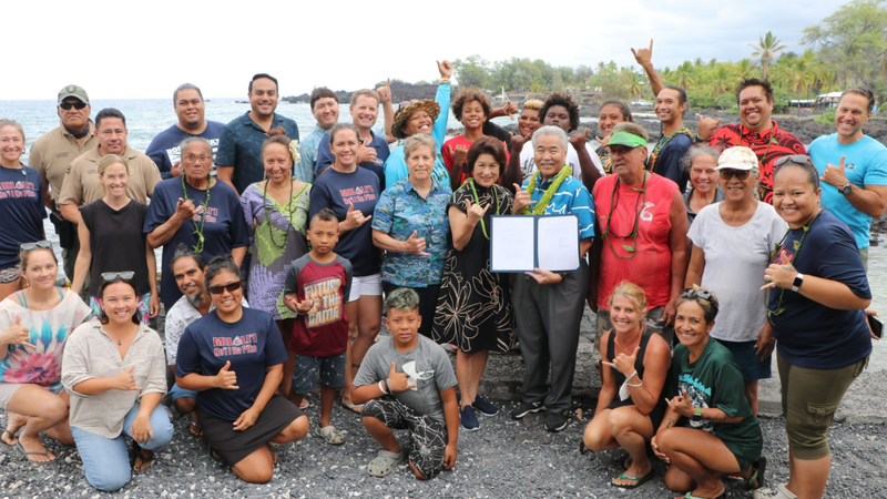
Miloliʻi Village community members, Hawaiʻi Department of Land and Natural Resources, and supporting NGOs join Governor David Ige in celebrating the establishment of the Miloliʻi CBSFA in August 2022 (Credit: HawaiiMERC)
A year prior to the official establishment of the CBSFA, the M2 system was positioned at the northern entrance to the CBSFA and has been tracking the number of vessels entering the area since its deployment. A geofenced zone configured in M2 software automatically flags vessels that enter the CBSFA within 3 nautical miles of the coast. A recent historical analysis showed that vessel traffic dropped following the CBSFA's establishment. Thanks to community outreach by Miloli'i Village and local volunteers, the M2 system documented a 58% decline in crossings into the broader area and a 68% decline within the coastal geofenced zone. Data collected by the M2 system before and after the establishment of the CBSFA help demonstrate the positive impact of the community’s efforts to conserve rich biodiversity and their traditional practices.
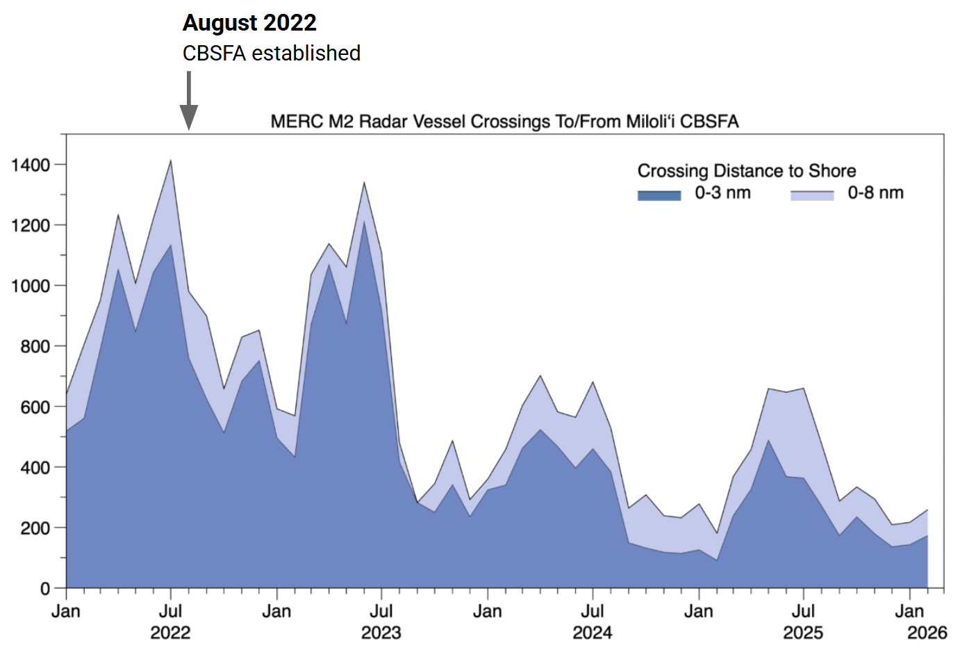 Vessel crossings into and out of the Miloliʻi CBSFA region at 3 nm and 8 nm distance from shore depicting the decrease in boat traffic (Credit: HawaiiMERC)
This M2 system was deployed in partnership with HawaiiMERC and Global Conservation and is managed by HawaiiMERC in support of Miloliʻi Village. Hawaii MERC is committed to supporting the iconic people and rich coastal and coral reef biodiversity of this area for future generations. Read the full story from Miloli'i Village members and HawaiiMERC here:
Nicoya, Costa Rica: M2 Provides NGOs with Vessel Traffic Data to Advocate for Protection
Along the southeastern Nicoya peninsula in Costa Rica, an M2 system monitors a remote area of the Pacific coast. Situated between the Camaronal and Carletas Ario MPAs, M2 monitors a highly productive marine corridor that supports multiple species of endangered sharks and sea turtles. But the area between the two MPAs lies unprotected, including the Corozalito nesting beach where tens of thousands of turtles lay their eggs each year. The M2 system was deployed in 2022 by the Center for the Rescue of Endangered Marine Species (CREMA) to measure the presence of fishing and diving activities in the unprotected area.
During the first year of data collection, hot spots of vessel activity emerged in different areas depending on the season. Activity was concentrated just offshore of the nesting beach in winter and both inside the Camaronal MPA and the unprotected area in spring. As the year progressed, this activity persisted, but other activity farther offshore expanded throughout the summer. While M2 documents vessel activity, CREMA conducts simultaneous monitoring of shark, turtle, and ray populations to understand how they use the area. CREMA shares these datasets with Costa Rica's National System of Conservation Areas (SINAC) annually to advocate for the establishment of new MPAs and the need for effective management of these species and their habitat. While the Costa Rican government has yet to expand these areas, continuous monitoring and long term quantitative datasets produced by M2 are valuable for supporting the need for increased protection.
This M2 system was deployed in partnership with CREMA. Take an up close look at their impactful work in a video here:
https://www.youtube.com/watch?v=y-RTkoD3hXQ
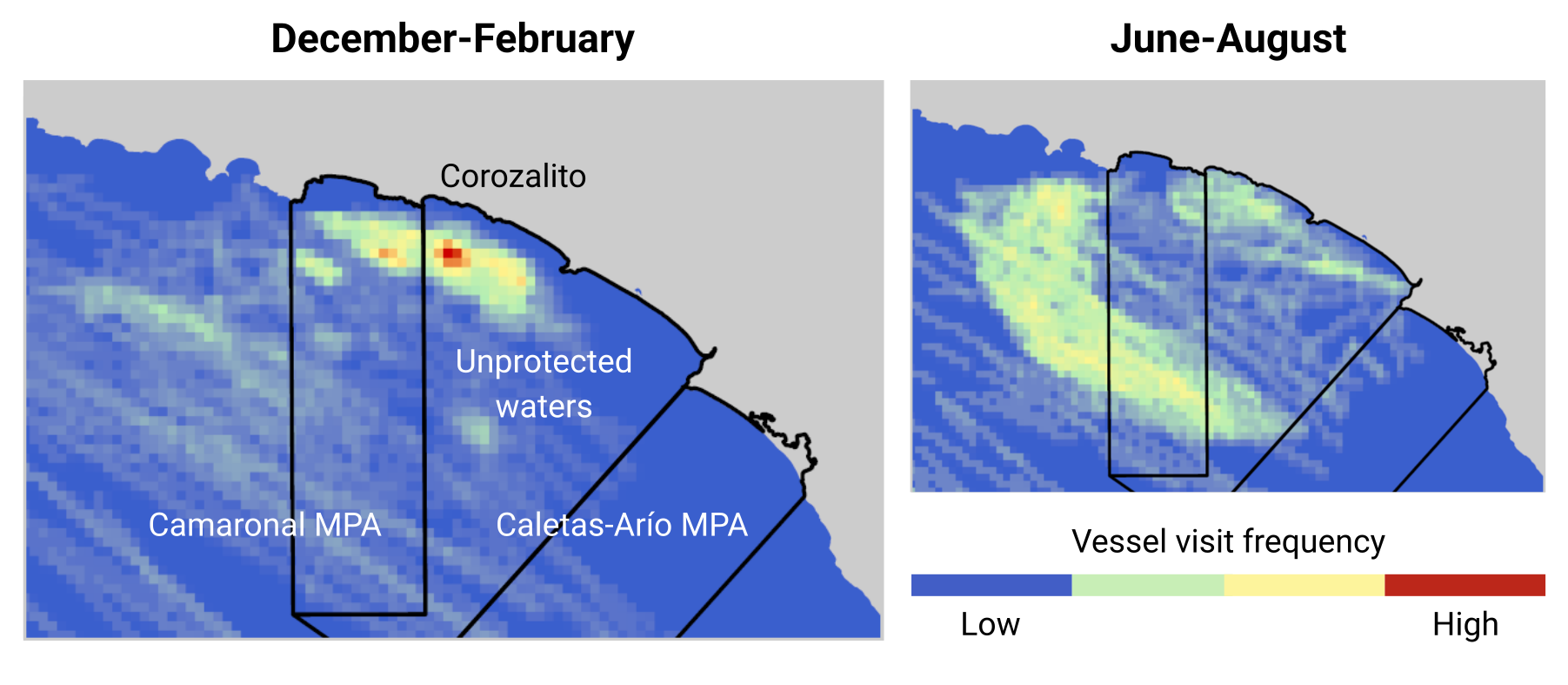 Hot spots of vessel activity in both MPAs and unprotected waters along the southeastern coast of the Nicoya peninsula in Costa Rica
All M2 deployments require concerted effort by our partners who care for, monitor, and protect marine ecosystems. Thank you to all of our partners who manage these and other M2 systems around the world, for their dedication to protecting biodiversity for future generations, and for their inspiration!